The Greenway
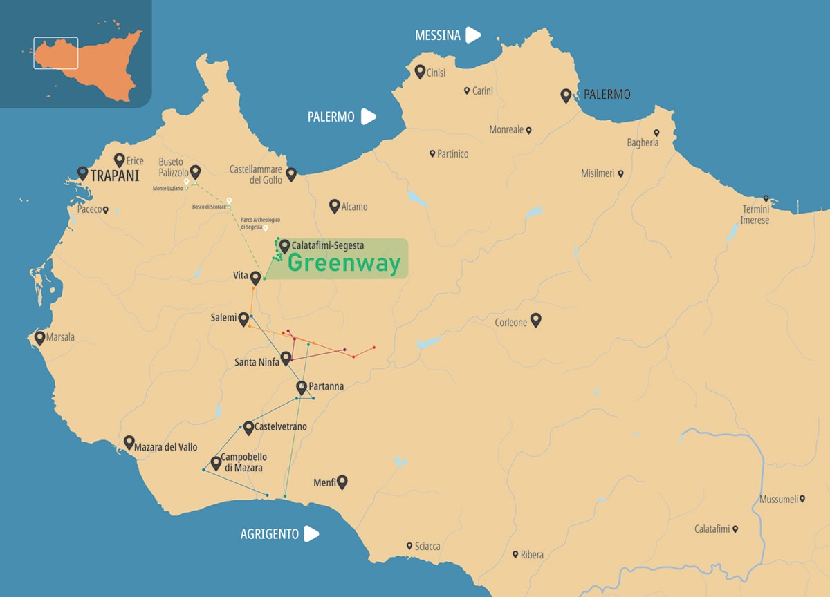
Creating an environmentally friendly network of alternative transport system, known as “slow mobility,” by using decommissioned railway lines and minor roads. This is the concept that originated from the non-motorised mobility plan approved in Sicily in 2005 by the Regional Department of Tourism, Communications and Transport.
In this context, such a concept was conceived to transform the “Salemi-Kaggera” Fascist-era railway section, which was left unfinished and never operational, into a striking “green line” or “Greenway”. An easy route for cyclists and walkers, surrounded by a charming landscape, that recounts the story of Trapani’s inland. A never-ending journey of discovery that makes it possible to learn about remarkable historical-monumental, archaeological, and geological testimonies, as well as to admire lush orange groves, vineyards, and olive groves, artifacts connected to the world of farming and sheepherding, and civil engineering structures belonging to the railway line itself.
The Trapani Greenway is also a strategic hub for six offshoot routes: one leading to Buseto Palizzolo via the charming Scorace forest, and five more routes marked by the Belican Museum and Nature Network. In particular, these routes cover anthropological, archaeological, natural, contemporary, and memorial aspects, providing a unique interpretation of Mediterranean civilization from ancient times to the present day.
Sites of interest along the Greenway
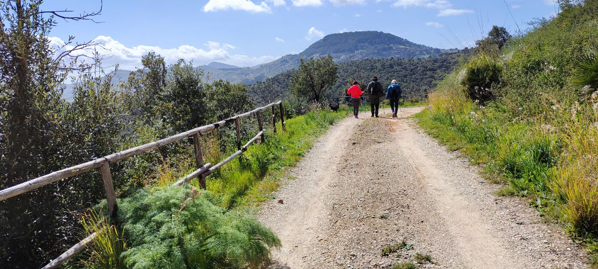
Angimbè forest
The Bosco Angimbè, located about 4 km north of Calatafimi Segesta, is one of the most enchanting natural places in this region. This wonderful green area extends well over 200 hectares, offering a vast territory in which to immerse oneself in unspoilt nature.
is the perfect place for hiking and trekking in the Calatafimi Segesta area. Paths dotted with large shrubs lead through this scenic wooded area.
Guided tours and seminars are available, ranging from the promotion of this magnificent place to raising awareness of environmental issues, with courses on botany and mycology.
Inside there are ideal spots for picnics, children’s games and areas with fire spots.
The fauna of the Bosco Angimbè is rich and varied, with numerous species of mammals, amphibians and a large presence of migratory birds. It is an ideal place for birdwatchers.
Over 700 botanical species grow here, including cork oaks, holm oaks and some endemic plants found only in this area.
Segesta Archaeological Park
Sanctuary of Contrada Mango
Among the city’s sacred areas from the Archaic and Classical periods, in addition to the one on the Western Hill with the large Doric temple, there was also the extra-urban sanctuary of Contrada Mango, the ruins of which can be seen from the path. Located on the south-eastern slopes of Mount Barbaro, in a naturalistic setting of great value, the sanctuary overlooks the Vallone della Fusa and the Gaggera river, which profoundly marks the sacred landscape. The sacred area was sumptuous and monumental. Within a mighty wall of enclosure and terracing stood a large Doric temple (28×56 m): a periptero (surrounded by columns), with a pronaos (vestibule), cella and opisthodomos (back room). The building, which is preserved at foundation level, has been dated to around the mid-fifth century B.C. and linked to Selinuntine architectural culture. It is the first peripteral temple built by the Segestan community. From the sacred area come Greek vases, locally produced ceramics, fragments of marble sculptures and metal objects, including numerous bronze and iron weapons. The sanctuary was frequented by men and women during individual and/or collective rituals. The identity of the deity to whom it was consecrated remains unknown.
It can be visited by accessing the Segesta Archaeological Park.
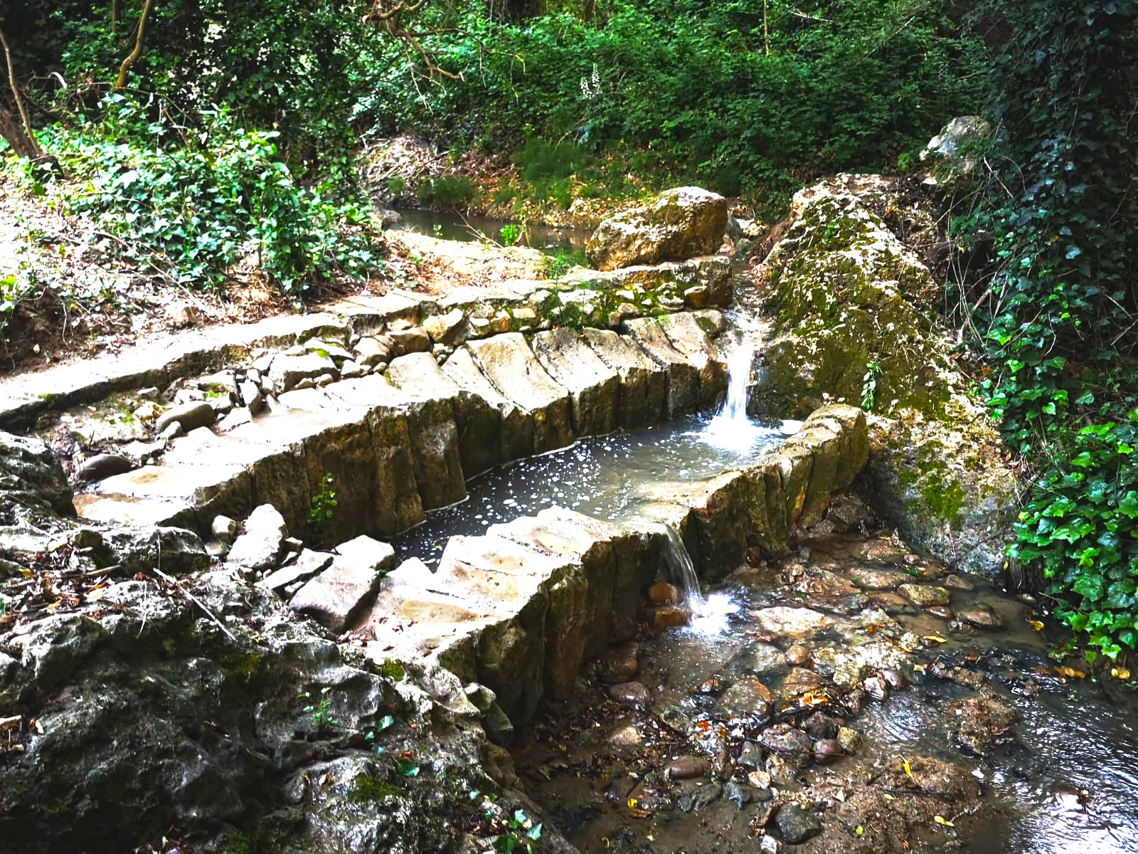
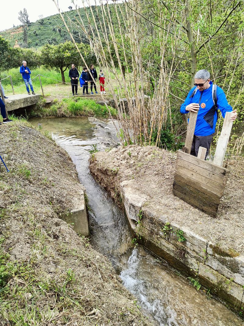
The ‘Kaggera Gardens
They preserve various testimonies of ancient irrigation systems, of Islamic tradition, which document the perfect relationship between natural balances and human action established over the centuries. A place where silence reigns, accompanied only by the sound of water. In addition to the gebbie and cube, the agrarian landscape is also characterised by the zachie, or channels that conveyed water from the Gaggera river to drive the mills, located along its course, and ensure the irrigation of the surrounding land. The flow of water was regulated by a wooden sluice gate called ‘zappeddu’ in dialect.
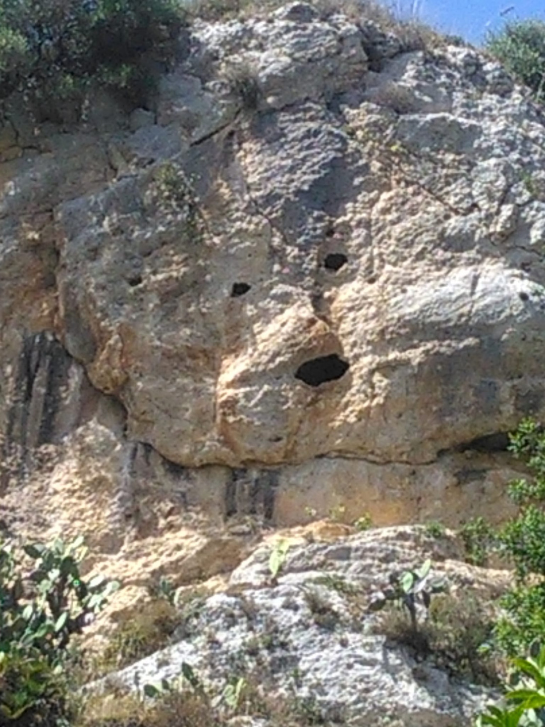
Also related to the skilful use of water is the impressive linen washhouse, used in the past for washing clothes and later also for retting linen, cultivated in the Calatafimese countryside until the 1950s. Particularly fascinating is the so-called Mouth of Truth, three natural openings in the rocky ridge that seem to draw the eyes and mouth of a mask.
Along this stretch of the route you can admire centuries-old olive trees and lush citrus groves, cultivated using traditional methods, that produce the Ovaletto di Calatafimi, an oval-shaped, seedless blond orange with a particularly fragrant peel. It is a late cultivar that ripens in spring. The Ovaletto has been included by the Ministry of Agriculture and Forestry in the list of regional Traditional Food Products.
Patti Bridge Station
Along the disused railway line remains the intermediate station of Ponte Patti, a simple and functional building, conceived to serve the present-day town of Calatafimi-Segesta. From this point, a visit to the town can begin.
Antica Trasversale Sicula and Via Francigena Mazarense
From this point, one can enter the Antica Trasversale Sicula, a long path from Camarina to Mozia, and the Via Francigena Mazarense. Two routes, between history and nature, that reveal the richness and cultural variety of Sicily.
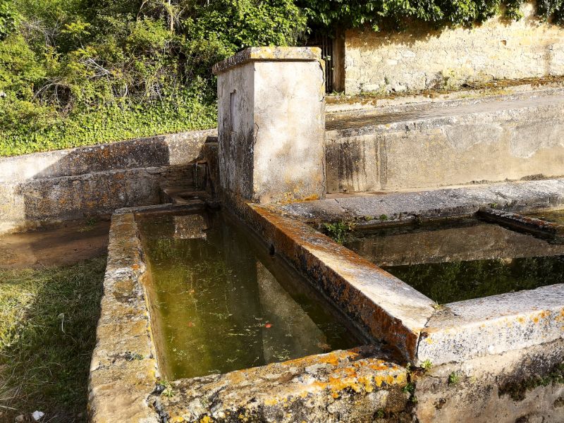
Contrada Canale drinking trough and Contrada Rio drinking trough
Symbols of ancient rural culture, drinking troughs are stone or masonry tanks that supplied water to the flocks, herds, pack animals and men passing through the countryside, where the architectural elements were in symbiosis with the landscape. Often used for irrigation purposes, the bevai in some cases also functioned as wash houses. They could be placed next to a fountain and decorated with short epigraphs, coats of arms, sculptures and images of a sacred character. Despite the simplicity of the forms and materials used, the troughs show effective technical devices to convey water from the springs, exploiting its natural fall, and to allow it to be drawn.
Along the disused section, one encounters the Contrada Canale trough and the Contrada Rio trough. The Contrada Canale drinking trough, to which a simple fountain is attached, consists of a complex system of interconnected tanks and overflows that poured water into the canal and then into the river, an extraordinary example of water management in the Islamic tradition. Inserted in the wall is a bas-relief depicting the Madonna and Child, recalling the iconography of the marble triptych preserved in the Church of the Madonna di Giubino in Calatafimi-Segesta. The Madonna has a very close link with the rural world: every year, on the second Sunday in July, the Madonna in her wooden coffin is transported to her country sanctuary where she remains until the third Sunday in September, when she returns to her city sanctuary. The wall of the monumental trough in Contrada Rio bears the date 1948, the year in which it was built or more probably restored.
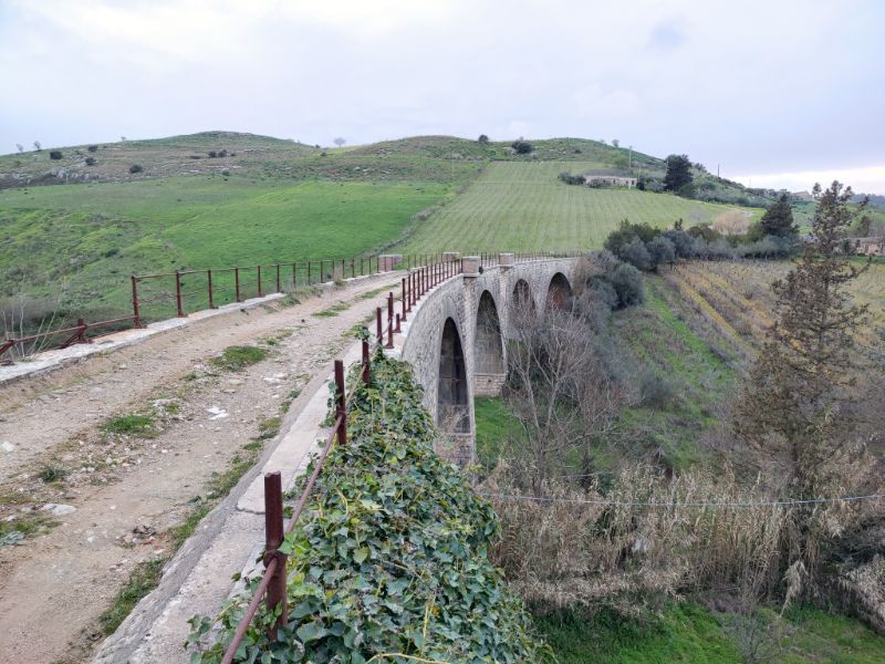
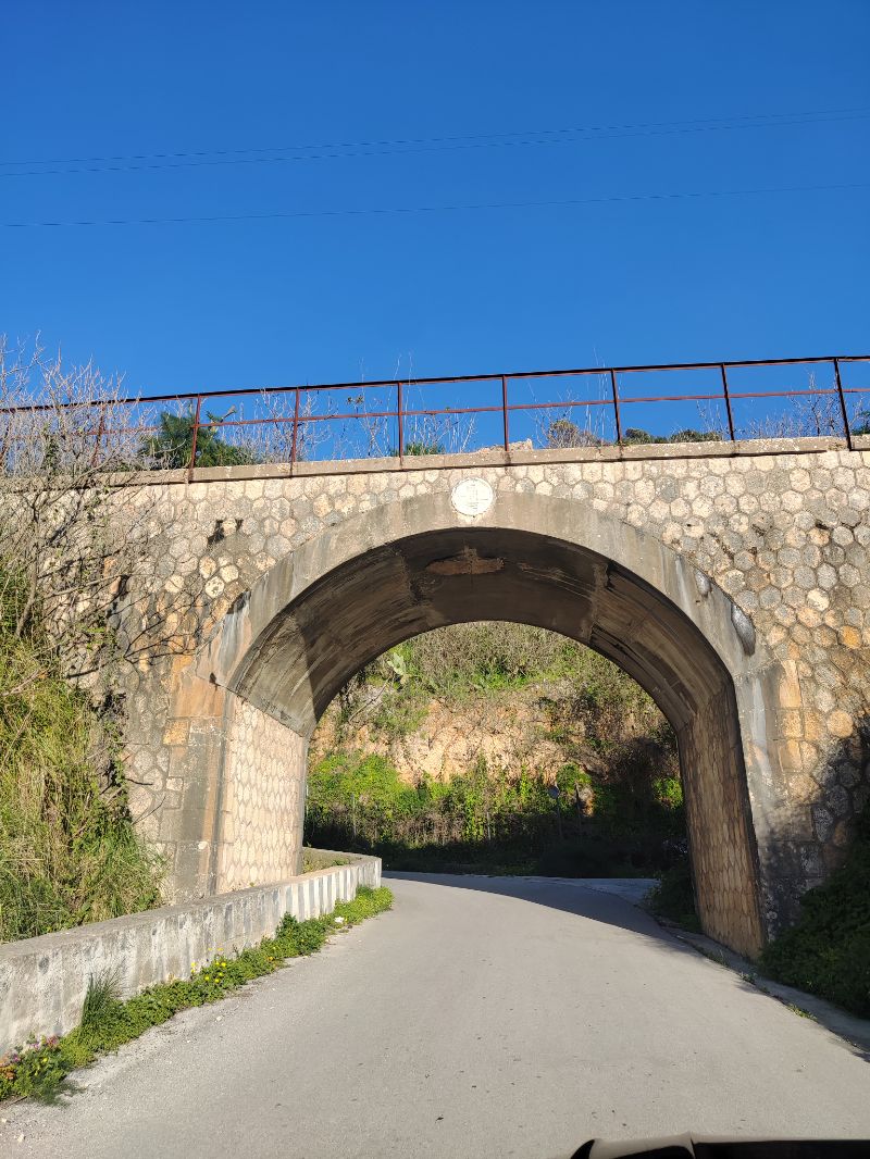
Civil engineering works
Along the route, there are various architectural artefacts related to the operation of the railway line that retain their engineering value intact. Of particular value are a long stone retaining wall with blind arches, a five-arched bridge with an iron railing and balconies with brick balustrades, built for safety reasons, and a subway that preserves the roundel with the fascio littorio (fascio littorio) and the indication of the year of construction (1929).
Chalks of Contrada Margi
This is a second-cycle chalk formation (Pasquasia Chalks) datable to the Upper Messinian. They are selenitic macrocrystalline chalks, with the typical ‘spear-iron’ gemination, immersed in a chalkarenitic and gypsum matrix. The area is of particular geological interest and of great scenic significance. The raw material for the gypsum industry is extracted from these gypsum sites near Pianto Romano.
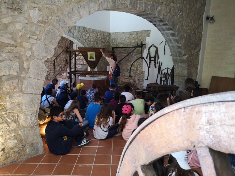
Archpriest’s Mill
One of the most striking places in the Calatafimi area is the Archpriest’s Mill, recovered by a private individual thanks to funding from the G.A.L. Elimos. The hydraulic, horizontal-wheel mill is named after Antonio Brandi, archpriest of Calatafimi between 1590 and 1661, who founded the Casa delle Orfane (House of the Orphans), to which, among other things, he assigned as dowry the fruits of his own mill, called the ‘Garamboli’ at the time. It was part of a network of water mills, fed by a network of canals (zachie), that grew up along the Gaggera river. From this presence derives its ancient name of ‘flumen molendinorum’, or ‘river of mills’.
It is possible to visit the interior of the mill and learn about the process of milling wheat to produce flour.
Roman Wailing Monument
On the top of the hill known as ‘Pianto Romano’ stands the commemorative monument of the same name, built to house the remains of the fallen soldiers of the bitter battle of Calatafimi fought on 15 May 1860, along the western slope of the hill, between Garibaldi’s troops and the Bourbon forces, a decisive event for the Unification of Italy. The shrine, designed by Ernesto Basile, was inaugurated on 15 May 1892 on the occasion of the 32nd anniversary of the clash. The pyramidal base, with elements reminiscent of the temples of the classical world, is decorated on the sides with two bronze groups by Battista Tassara, depicting the landing of the Thousand at Marsala and the Battle of Calatafimi, and is surmounted by a tall obelisk adorned with a bronze crown with the Trinacria and two palm trees. Behind the monument is ‘Il Viale della Rimembranza’ (The Avenue of Remembrance), which leads to a stele placed there in 1960, on the occasion of the centenary of the battle, on which can be read the famous phrase attributed to Garibaldi and addressed to Nino Bixio: ‘Here you make Italy or die’.
On 15 May each year, the municipal administration of Calatafimi-Segesta commemorates the historic battle in the presence of local authorities and others from various municipalities in Italy and the town’s community.
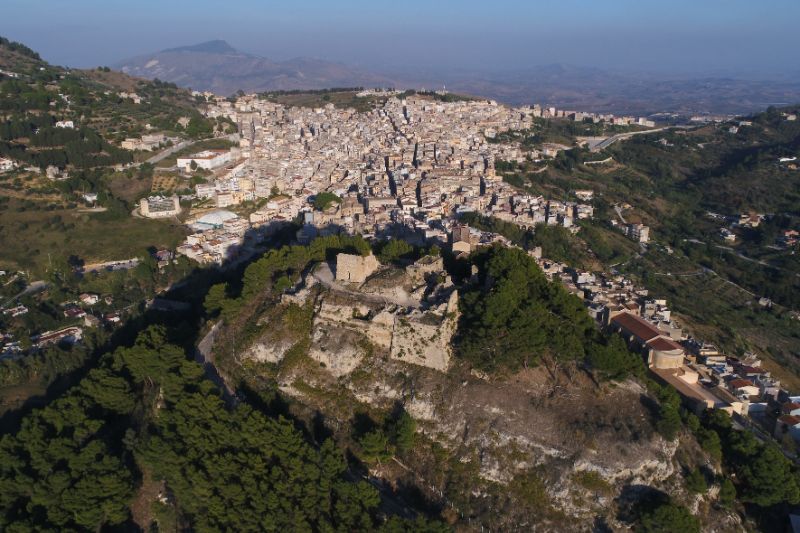
Municipality of Vita
The municipality of Vita lies at the foot of Mount Baronia. It is the smallest village in the Trapani area and, after Erice, the highest municipality in the province. The birth of the village is linked to its founder, Vito Sicomo di Calatafimi (1548-1626), who held the highest office in the Kingdom of Spain.
The village is adorned with fine fountains and numerous murals, created by contemporary artists, decorating the walls and portals of old uninhabited houses. The Daidone palace, built around the end of the 19th century, is one of Vita’s most important buildings as an expression of the local landed bourgeoisie. The most famous church is dedicated to Our Lady of the Rosary, known as Madonna di Tagliavia, whose origins date back to a prodigious event in 1896. The present church was built in 1933. The cult for the Madonna of Tagliavia, depicted in a painting inside the church, originates from the Marian shrine of Tagliavia in the Corleone territory, where the peasants and massari di Vita (farmers and landowners of Vita) would accompany their animals to receive a blessing. The feast is celebrated every year on Ascension Day. Worthy of note is the Church of St Francis, with the adjoining convent then dedicated to Our Lady of the Conception, built in 1619 at the behest of Baron Vito Sicomo. Part of the convent now houses the offices of the municipality. A short distance from the town, on the top of Mount Baronia, once a fiefdom of the Sicomo family, there is a mainly coniferous forest covering almost 67 hectares, an ideal place for picnics, hiking and mountain biking.
Thematic routes to take from the greenway
Archaeological Itinerary
An archaeological itinerary in Belìce cannot but start from the Archaeological Park of Selinunte and the Quarries of Cusa, one of the most important in the Mediterranean for its location, perfect integration into the landscape, and the grandeur of its temples. From prehistory to the Greek era, from the Elima culture to the medieval one, the latter recognizable in the Entella fortress and the Pignatelli necropolis in Menfi. In the Prehistory Museum of Belìce in Partanna, vases of the bell-shaped style, remains of fauna, and funeral furnishings from the necropolises of the archaeological area of the Strait tell the civilization of the ditches. In Castelvetrano, the Civic Museum exhibits the famous Selinunte Ephebe, a bronze statue of exquisite workmanship (480-460 BC), along with vases, lamps, and a lead plate (Lex sacra) inscribed with a law from the 5th century BC. The Antiquarium of Entella in the municipality of Contessa Entellina and the Antiquarium of Monte Adranone in Sambuca di Sicilia collect numerous objects from the ancient history of this territory. Segesta, from the top of Monte Barbaro, is one of the most important indigenous centers in Western Sicily, constituted by the Elimi from a people of peninsular origin. This city played a predominant role in the historical events that led to repeated struggles with Selinunte, which surely sought to gain access to the Tyrrhenian Sea. During the first Punic War, it allied with the Romans.
Anthropological Itinerary
In Salemi, the Risorgimento Museum documents the role of this territory in the battles for the Unification of Italy with clothing, weapons, and documents from the Garibaldi period. The new Ecomuseum of Wheat and Bread, instead, enhances and promotes the collective memory of a community linked to the tradition of ritual breads and ancient grains. The Small Agroforestry Museum of Monte Finestrelle, in the territory of Gibellina, recounts the traditions of Belìce through objects and tools linked to peasant culture. In Santa Ninfa, the Emigration Museum tells the story of the exodus to other countries in the first half of the 19th century. In Santa Margherita di Belìce, the pages and stories of the Leopard are relived through the manuscript of Giuseppe Tomasi di Lampedusa’s famous text, while the EthnoAnthropological Museum of the Land of Zabut in Sambuca offers visitors the educational setting of the wheat and milk transformation cycles.
Contemporary Itinerary
A journey into contemporary art can only begin from new Gibellina and Baglio Di Stefano, home of the Orestiadi Foundation, through visits to the Museum of Mediterranean Weaves, the Contemporary Art Museum “L. Corrao,” and the new city, a true “open-air museum” that allows us to enjoy one of the most important contemporary art collections in Europe, the result of solidarity among artists from around the world for the city’s reconstruction. From Gibellina towards Santa Ninfa, where the Nino Cordio Museum offers the collection that the great master donated to the city, and continuing through a landscape of particular beauty, you reach the great Cretto by Alberto Burri, created like a large shroud over the ruins of Gibellina, destroyed by the earthquake. The contemporary itinerary concludes in Sambuca di Sicilia with the textile works of the French artist Sylvie Clavel and those of Gianbecchina, which narrate agricultural traditions and the landscape.
Memory Itinerary
The youngest among the museums in the network is Belìce/EpiCenter of Living Memory in Gibellina, which tells of the struggles of the people of these lands starting from the march led by Danilo Dolci and Lorenzo Barbera in 1967 and then through the post-earthquake popular dissents and reconstruction. In Santa Margherita di Belìce, in the new building that incorporates the ruins of the Mother Church, destroyed by the 1968 earthquake, the Memory Museum has been set up, inside which images of the earthquake, newspaper articles of the time, and documents narrate the Belìce earthquake. Two structures that leave strong emotions in the visitor, the hardships, and the events of a people who must reclaim their identity and the beauty of the places they have lost. Some places in the Valley like the site of the old Gibellina with the Cretto by Alberto Burri and the ruins of Salaparuta, Montevago, and Poggioreale still preserve a certain charm of the past and the ruins.
Naturalistic Itinerary
Characterizing the particular landscape of the Belìce Valley are the natural reserves of Grotta di Entella and Grotta di Santa Ninfa, which allow you to visit and learn about the geological, vegetational, and faunal peculiarities through an excursion in the typical gypsum hinterland landscape of western Sicily that develops in the Rocca di Entella and the territory between Santa Ninfa and Gibellina. Places where the Belìce valley can be fully grasped up to reaching the Natural Reserve of the Belìce River Mouth and adjacent dunes, where on the coastal shore, dune flora reveals further naturalistic peculiarities. Along this territory, other places known more for archaeological interest linked to the prehistoric period such as the Stretto archeological area in Partanna and the Castello della Pietra in Castelvetrano allow you to see pristine nature preserved for centuries. Several forest areas between Castelvetrano, Salemi, Santa Ninfa, and Sambuca di Sicilia and in particular the Monte Genuardo Nature Reserve offer the possibility of enjoying and visiting vast wooded areas equipped for use. Particularly fascinating is the area of the Abbey of Santa Maria del Bosco near Sambuca di Sicilia in the municipal territory of Contessa Entellina.
Nature and landscape trail Buseto Palizzolo – Bosco
Scorace – Mount Luziano
The municipality of Buseto Palizzolo stretches on a strip of land between Erice and Segesta. Here, the scent of the earth can still be smelled by walking along the quiet paths through the green contradas with vineyards, almond groves, and olives.
Not to be missed, a stroll through the streets of the village, as well as two sites with naturalistic and scenic appeal: the Scorace woods, also known as Bosco d’Arcudaci, and Mount Luziano. By walking the paths that lead from the Scorace woods to the hillside lake – a true paradise at 646 meters above sea level – a panorama of rare beauty can be admired: from Bruca to Calatafimi-Segesta to Castellammare del Golfo. By climbing Mount Luziano, and reaching the peak, it is possible to witness a unique and incomparable view: Mount Cofano, Mount Erice, which stands over the Valdericina valley all the way to Trapani, the Palermo and Castellammare coasts, and even Mozia and the Stagnone of Marsala off in the distance.
Due to its geographical location, it is easy to reach by car the following places from Buseto Palizzolo: the town of San Vito Lo Capo (31 km), Trapani (16 km), the medieval village of Erice (18 km), and the town of Castellammare del Golfo (22 km).
Sites for in-depth analysis
www.comune.calatafimisegesta.tp.it
Download route tracks
GREENWAY – click here
ARCHEOLOGICO – click here
ANTROPOLOGICO – click here
CONTEMPORANEO – click here
MEMORIA – click here
NATURALISTICO – click here
CALATAFIMI, PARCO ARCHEOLOGICO DI SEGESTA, BOSCO SCORACE, MONTE LUZIANO – click here